Saturday, July 18, 2015

On our way to Explore the Western USA, Oregon, Washington, etc

At last, on the road again.  After a two year hiatus due to back surgeries, uggggh.  This year we are heading to the Oregon coast, with a loop through Yellowstone National Park.  It definitely is a big trip, 6000 plus miles, I feel lucky to be able to do it.  For the first time we will be traveling with another couple.  It should be great fun, with plenty of cool weather to enjoy.

After much work, our motor home is packed and ready to go.  I will be towing our new Jeep Grand Cherokee this year.  It will give us much more room for passengers and items in the back.

We will work our way across Texas, ever heading north, seeking the cooler weather.  We are planning on driving approx 300 miles per day, with day off, for the 10 - 11 days it will take to get there.  Our site seeing will be mostly in the west.

Driving day 1
We stayed in Alvord, Texas our first night.  A +RV Park.  A very simple RV Park, but conveniently placed on US 287 and had strong 50 amp service and a fast Verizon WIFI connection.  Good for an overnight stop.

Driving day 2
Our next stop was in Amarillo, Texas at the Oasis RV Park on I-40.  A nice RV Park, again located close to the freeway for easy access.  We stayed in site 16 while our traveling partners used site 15. We were so tired when we arrived, a quick vote sent us into town to eat at the Hofbrau streak house for a center cut steak....

Alvord, Texas to Amarillo, Texas


Albuquerque, NM, American RV Park, site 220

Driving day 3
We continued our journey to Albuquerque, NM, with a much needed rest stop.  We stayed at American RV Park.  It is a nice park located on the west side of Albuquerque.  We stayed in site 220.  It rained both days we were there.  The cool temperatures were great.


Tomorrow morning,(in the rain) we head out for Cortez, Colorado.  A small town in southwestern Colorado.  It has a KOA, not fancy (gravel/dirt parking) but an overnight stop on our way to Salt Lake City.

We continue to work our way across the USA heading toward the northwest Pacific Coast


Lee, standing at the entrance door of the coach
Cortez, Colorado.


View out our front window while in Cortez.


Driving day 4
Our destination of Cortez was achieved.  Weather was cool (65) and the site was had came with a suburb view.  We ate dinner in a small Mexican restaurant in town after a happy hour of sitting outside in the cool air.  We made plans for our next segment of the drive and had a drivers meeting in the morning.

Heading to Salt Lake City, Utah.


Albuquerque, NM to Cortez, CO.  268 miles, mixed driving conditions.
Hills and straight.

Driving day 5
Wow, what a drive.  We drove US 491 through Moab, then to IH 70.  IH 70 cuts west through some of the most picturesque country I have seen.  The freeway cuts through high country and the view out the front windshield is spectacular.  Once we hit Provo, a streak of bad luck hit us.  It started with "Mother of all Traffic Jams" on the south side of Salt Lake City.  For approx an hour, 5 to 10 mph, stop and go traffic.  It was terrible.  The Salt Lake City highway planners certainly missed the ball on this.

We had an issue with the rig.  The salon AC compressor locked up resulting in two belts being thrown.  I decided to wait until I am back in Livingston for repair.  Will use roof ac if needed.

Cortex, CO to Salt Lake City, UT.  430 miles, a very long drive, with
the mother of all traffic jams in Salt Lake City.


Driving day 6
After resting in Salt Lake City for a couple of days, we headed West.  On our way to Reno, NV, we overnight in Elko, NV at Iron Horse RV Park.  We had a nice meal at a local pub.  Headed out early the next morning, pushing west.  Plenty of open country in northern Nevada.

Stopped at a rest stop in the Salt Lake Desert


The famous Bonneville Salt Flats.  It sure is flat out here.

Salt Lake, UT to Elko, NV.  226 miles of high country desert driving.
Great Salt Lake, Great Salt Lake Desert and high country desert.


Driving day 7
Heading west to Reno.  Mining and cattle ranching seem to be the local economy.  Plenty of open country to see during drive.  Stayed in the Grand Sierra Casino Resort RV Park.  Near the Reno airport, so say plenty of aircraft takeoff and landings.

Plenty of wide open spaces.

Elko, NV to Reno, NV.  190 miles of high country desert driving.


Driving day 8
Heading to Redding, CA.  The drive in half way in the high coutry desert, then half in the mountains.  Will pick up my spare fan belts at an Autozone in Redding.  Arrived in Redding, man is it hot here, 110 degrees.   Did I mention it was hot here!  Whew, one more day to get to the coast  Can't wait for the cool weather.

Reno, NV to Redding, CA.  199 miles, pleasant drive, 1/2 mountain driving.


Driving day 9
Heading to the coast on California SR-299.  The road was very exciting with many curves and up's and down's.  The scenery with excellent during the drive.  As we approached to coast, the temperature dropped from 85 to 71 degrees.  The coolness on the Pacific Coast was very nice.
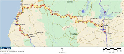
Map of route from Redding, CA to Redcrest, CA. 189 miles of mountain driving.

Our total mileage when we arrived in Redcrest, CA was 2,557 miles.  We rested two days in Albuquerque, NM and two days in Salt Lake City.  Not bad for an old guy.

Monday, July 8, 2013

Take Flight

At last, I have taken the time to pursue a hobby that has held my interest for many years.  I have had so many computer/software flight simulators, but they never captivated my interest.  However, my newest interest of "First Person Video" RC airplanes is the thing for me.  Simply stated, you fly an RC controlled electric airplane with tons of electronics on board.  The electronics has many capabilities, but the most interesting is the ability to transmit video back to a airplane tracking receiver that outputs video to a video monitor.  In other words, one can sit on the ground and see what a miniature camera mounted on the nose of the airplane sees.  It is like fling a real airplane, but you are safely on the ground.

Below is a small example of a flight taken locally while I am tuning all the controls on the airplane control system.  This is a long video, but it shows the capabilities of the electronics.  Also for a better viewing experience, be sure to click the "full screen" button on the lower right side of the video screen.

Enjoy, more to come.

Flight of Lake Livingston, Texas Area
To view full screen, click on the small "full screen" button in the lower right corner of the video screen.


Sunday, October 30, 2011

Edwards Estate Clovis New Mexico Farm

We have a friend and neighbor that has a farm/ranch within his properties.  And since we were traveling through the area, returning to Texas from the Northwest United Stated, we decided to stop.  The history of the farm is rich with family lure of hard working people creating working farms to generate income. 

Clovis, New Mexico is a very, very dry country and life only exists because of waterWater is the life blood of existence in this land.  Farms must be irrigated or they simply will not exist.


The Edwards farm is a piece of history that proves success from genuine human spirit.  The original "home place" is currently owned by what one would easily call "a New Mexico Cowboy".  It was great meeting the current owner and chatting with him and his son.  Our only regret is we wished we had more time to mingle with these guys.  These guys are definitely living the New Mexico Cowboy Way.


The farm buildings were scattered across approximately 15 acres (the old home place is owned by Donnie and the farm land by Edwards) with buildings for machinery repair, storage and cattle pens.  Used farm equipment was stored at various locations on the property.  Nothing goes to waste is a farming operation.  (You never know where that next needed machinery part will come from.)  The "sweet smell" of cattle barns was in the air as we walked around the property.


The ranch buildings are surrounded by circle irrigated farms.  Corn was the main crop we noticed.  However,  green beans and spinach have been grown as well.  While driving through the town of Clovis, we noticed pickup trucks were the main vehicle of choice.  Plus, opened rolls of barbed wire, shovels, hay, cattle feed and dogs were tools being carried in the pickup beds. 


It was truly a step into America's cattle country, with pickup trucks being used, instead of horses and Wal-Mart visited instead of the general store for supplies.  Cattle was also part of the daily activity.  Cattle is purchased and allowed to graze the fields at various parts of growing crops.  These fattened cattle are then sold for profit.  Income from the use of land is maximized.


My finial comment is ranching and farming is hard work!  These guys are committed to live a life of hard work to generate income from their land.    I am sure that after a long work day in a dry dusty field or following a herd of cattle stirring talc powder fine dust, the romance of the cowboy way is deminished.  However,  a clear "value added life" is seen for growing and living life in this environment.  I certainly "tip my hat" to these guys.


Lee and I very appreciative for the genuine hospitality of the current owners sharing a small "snippet" of their lifestyle with us "Texas Drugstore Cowboys".  We will always remember our brief stop at the Edwards Farm and visiting with Donnie and Chad in Clovis New, Mexico.

(Click on pictures for enlarged view)

Welcome to New Mexico Sign.  Notice the beautiful mountain range in the background.

At the farm, Jaycee and XXXXX pose with their pup.

XXXX was wearing his championship roping belt buckle.  He and his dad are rodeo roping competitors.  We were definitely in cowboy country.

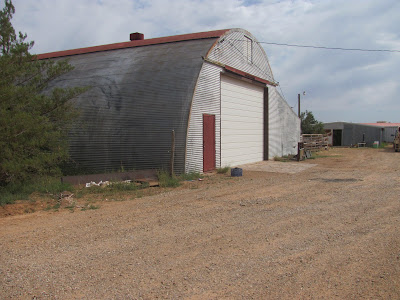
The long barn.  This barn is adjacent to the cattle pens.

Picture of the ranch taken in 2007.

Picture of the ranch taken when purchased by Donnie.


Donnie in his ranch office.  The office was loaded with memobilia.

Cowboy memoribillia.

This is a saddle won by Donnie and XXXX for their championship roping.

Check out the video clip we filmed while on the property.  We loved being there and appreciate the genuine hospitality.


Tuesday, August 23, 2011

Mt. Saint Helens National Historic Monument

Mount Saint Helen's eruption was the largest explosion in the history of the United States and it happened during my lifetime.  It was a must see for both of us and we were not disappointed. 


A well deserved comment concerning the National Parks Service.  Mount Saint Helens is considered a national monument, thus, it is managed by the national parks service.  Of all the national parks we have visited, this is the best.  They have done a great job of presenting and describing the events surrounding Mount Saint Helens eruption.  Well Done!


A visitors center operated by the state of Washington that describes events concerning Mount Saint Helens is the first stop along HWY 504..  Highway 504 from I-5 goes 50 plus miles into the interior of the Cascade Mountain Range to a location called the David Johnston Observatory. It faces the area of Mt St Helens that "blew out".  Although located 5 miles away from the crater, it is perfectly located for excellent views of the volcano.  The David Johnson Observatory is named in honor of a Volcanologist that lost his life during the eruption.


An eruption column rose 80,000 feet into the atmosphere and deposited ash in 11 U.S. states. At the same time, snow, ice and several entire glaciers on the volcano melted, forming a series of large lahars (volcanic mudslides) that reached as far as the Columbia River, nearly fifty miles (eighty kilometers) to the southwest. Less severe outbursts continued into the next day only to be followed by other large but not as destructive eruptions later in 1980.

We were fortunate enough to met a couple that lived only 50 miles from Mt St Helens during the eruption.  They stated that ash covered their yard and plugged their gutters.  It took several months to clear and wash the abrasive ash away.


Another interesting fact is the Mount Saint Helens contains the only actively growing glacier in the United States.  The shape of the volcano crater provides shade to parts of the crater that provide the perfect environment for ice glacier growth.  A glacier has grown around the volcano vent and is growing down the face.  The glacier is gray or ash colored.


The drive to the Mount Saint Helens David Johnson observatory is very notable.  A narrow highway climbing the rich timberland of the Cascade Mountains was a very nice drive.  Lee and I both rode with our windows down enjoying all the smells and scenery of mother nature.  The trip is over an hour long to the observatory, but well worth the effort.

We stopped at the Mount St. Helens Visitor Center located on the route taken to the "David Johnson Observatory" located at the eruption site.  It is well done, but is operated by the state of Washington, not the Parks Service.


One of the displays showing genealogist at work.


More displays.


Lee at our lunch stop.  We had a great view of Mt. Saint Helens and a very busy helicopter pad used to ferry tourist to fly over the mountain.

Our view.

Lee and Mt. St. Helens in the background.  Note the ash debris in the valley behind Lee.  This is after 30 years since the eruption.

Mount Saint Helens view during the drive up the mountain.

At the David Johnson Observatory one of the many remnants thrown by the force of the eruption.  Note the roots were torn from the ground.  We are five miles from the volcano and destruction is still very evident.

This is a picture from the theater located in the David Johnson Observatory.  The parks service has done a great job with how they have done this.  A video presentation is given indicated what led up to and the actual eruption.  After the movie, the screen rises and our the windows, you see the actual mountain.  Very well done!!

An occasion worth commenting on, I received by Golden Age Pass.  I am not sure if I should celebrate or cry.  Lee refused to get hers.  She said no way, I'm not their yet!

This was taken my Lee.  She sees these signs as we travel.  I will not comment any farther.

Hector with Mount Saint Helens in the background.  The drive up the mountain was well worth the effort.  Driving in the remote high country of the Cascade Mountains is a treat.

Monday, August 22, 2011

Bonneville Dam

While in the Portland, Oregon area, we drove east on I-84, through the Columbia River gorge, to Bonneville Dam.  This dam was built during the depression and prompted by President Roosevelt.  The facility also has the largest fish hatchery in the Northwest.  We toured the fish hatchery and enjoyed learning all the processes that lead to populating fish throughout the northwest.

A Sturgeon fish is a huge fish that can grow to 10 feet long and weigh over 450 pounds.  These fish are related to fish from the dinosaur age.  When looking at the Sturgeon fish, with bony skeleton that protrudes to the side of the fish, it is understandable how the fish could have survived throughout the ages.  The hatchery has a sturgeon fish they call "Herman" in a large tank.  He is over 10 feet and weighs 450 pounds.  He is over 70 years old.  What an animal!
The Bonneville Dam also has a Power House that uses water behind the dam to spin huge electric generators that provide power for the northwest.  The power house has a capacity of over 525 megawatts.  The powerhouse has been upgraded over the years to its current capacity.  The visitor center also had fish ladders for several varieties of fish that migrate to the upper levels of the lake behind the dam.

The fish hatchery and dam are open year-round from 9:00 am to 5:00 pm. It is best to visit the dam in the months of April through September when the salmon are more abundant.

There are fish viewing windows and visitors' centers on both the Oregon and Washington sides of the dam. Because of security concerns, visitors may be required to show ID, and it is not possible to cross the entire dam. During most of the year, more fish use the Washington shore fish ladders, so fish viewing may be better on the Washington side of the dam.


From I-84, we see sign for Bonneville Dam.  We had a beautiful drive through the Columbia River gorge to get to Bonneville Dam.  A great drive with wonderful views.

We found a place to park the rig for the day at Bonneville Dam.

Lee thought the flower displays in the fish hatchery grounds were beautiful.

This is a picture of Herman.  A sturgeon fish that is kept by the hatchery.  He is over 70 years old, 10 feet long and weighs over 450 pounds.  His head is over 12 inches across.


I had a telephone call while at Bonneville.  What a great place to take a call.  The temperature was 70 degrees.

Driving on the dam roadway on our way to the Bonneville Dam visitor center.  Definitely, a "concrete mans" dream.

Lee standing next to one of the water turbines that are used in the Bonneville Dam to turn one of the huge generators.

This is a "pill box" used by guards during World War II.  This dam was one of the resources used by the United States to power factories used to build the war machine.

Ten huge generator used at the Bonneville Dam.  The noise was deafening in the building.  Note the small bicycle in the front left of the first generator to see a size reference of these huge machines.

Discharge of the power house.  It should be noted that at Bonneville Dam, a powerhouse releases only a part of the water coming down the Columbia.  A separate overflow dam controls the reservoir level. 

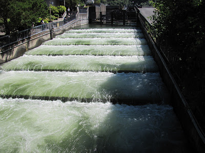
A fish ladder used by fish to migrate to the upper levels of the reservoir.  The fish used under water holes in the ladder walls to go up.  Fish are attracted to this fish ladder by controlling the entrance flows that attract fish swimming up.