I decided to stay a week in a "Northwest Pacific beach town" to see the lifestyle of the residents living there. Long Beach is one of several small towns that are on a long peninsula on the Pacific Ocean, in the extreme southwest corner of Washington state. Long Beach, Ocean Park and Ilwaco are three of the small towns on the peninsula. Ilwaco is the port town with a small harbor that gives fishing boats access to the Columbia river and the Pacific ocean. Long Beach is the tourist area and Ocean Park has Jacks Country Store (famous for having "what ever you might need"). There is one main street that goes down the center of the narrow peninsula through all three towns. These beach communities are remote and somewhat isolated. Tourists were here, but not in huge volumes.
Oysterville in the most historic community on the pennisula. It was not an active town, but housing for the business "Oysterville Sea Farms".
The draw for me to the beach was the temperate weather. At night temperatures were in the 50's and low 70's during the day. We drove the length of the peninsula while driving on the beach Sunday. Washington state allows vehicle traffic on the beach. What a great drive it was.
The small towns on the peninsula exist from tourist trade. On weekends, people from Portland come to the peninsula to enjoy the beach. We saw numerous people in the cool waters onfthe ocean, but for us Texans, it was too "chilly".
Our time here is will be remembered with cool weather and good seafood. Plus, we took our dogs on the beach for a day of play. Both enjoyed the open beach. Lucky was afraid of the waves. She is soo funny.
We stayed at Anderson's RV Park in Long Beach. It is located on the beach and in my opinion is the best game in town. There are also other RV Parks on the peninsula.
Harbor at Ilwaco with all sizes of boats. There was a seafood cannery located in the harbor. This the only deep water harbor that connects to the Pacific on the peninsula.
Birds on the beach. Seagulls and some other larger birds all mingling.
Lee, Goober and Lucky on the beach. Both dogs enjoyed the beach. Lucky was scared of the waves.
Goober loved to lay her belly on the cool sand. Both dogs were covered in sand when the day was done.
On Wallapa Bay, oysters have been harvested for over 60 years. The bay has huge tidal flats that are used to plant oyster seedlings. Oysterville is a historic town that claims to have the oldest post office in Washington.
Here is is a group of mule riders on the beach. They were leading riderless mules that were in training.
Click on the short video to see the sights of a small beach town located in the southeast corner of Washington state. The peninsula is on one side of the Columbia River where it joins the Pacific Ocean.
From Long Beach, we will travel to Portland to replenish our stock of supplies, before traveling farther down the northwest coast.
While in the area of Seattle, the Boeing Aircraft factory is a must. Boeing has a facility called "The Future of Flight" as a launch for their tours. The facility houses numerous displays of aircraft features, an auditorium, security, a company store and a facility for bus traffic for the tours.
The displays inside the facility were interesting, but the main item was the factory. Unfortunately, cameras were forbidden in the factory. So no pictures of the factory, but a few facts. The building were the 707,727,747, 757,777, and the 787 are made is huge. The building is the largest building in the world by volume. It covers 98 acres and 30,000 employees work there on three shifts. There are tunnels that run underneath the facility for getting from one side to the other. Numerous overhead cranes do the work of moving the huge pieces of the aircraft. The 787 is a composite aircraft, not aluminum. The factory looked like a well orchestrated city of planned movements.
A Boeing 787 can be purchased for $350,000,000. Of course, options are extra.
Front entry doors into Boeing's Future of Flight Museum.
A photo from the top of the Boeing gallery. Interesting displays.
One of the many information boards.
Here I am "flying" as a passenger on a jet.
I was not good enough to sit in the seat as a passenger. I needed to look outside.
This shows one of Boeing's corporate jet furniture settings. They use this in their 737 aircraft. Lee asked why can't our jet-setting neighbor have a jet like this. Well, David???
Big tires!
The next engine for my bus.
Lee wondering what will be the gas mileage of this thing?
Nothing is free. Boeing operated the visitors center like a for profit business.
One of the reasons I do not like Seattle is this. The traffic was terrible, everywhere we went.
Sitting behind our coach having an afternoon drink. These guys are normal RV park visitors. Almost feels like home...
After we left Grand Coulée, we traveled down the Banks Lake looking at all the growing fields of wheat on each side of the reservoir. We then turned west on Hwy 2, heading into Cascade mountains. The height of 4056 feet is certainly not as high as the passes in Colorado, but the scenery is equally spectacular.
The word "green" comes to mind when you travel this area. Especially, after having passed through the eastern desert of Washington state. Everything was growing and water was rushing! Each time we stopped along the way, we would be on the side of a fast flowing stream. The sound on the rushing clear water is so appealing.
We tried to get Lucky to get into the water, but no luck. She was so scared of the noise and the tiny ripples on the shore edge. She did manage to get a very nervous drink of water from the fast flowing stream.
The drive over the Cascades on Hwy 2 was very rewarding with more scenery that I will ever remember.
We were surprised to see water rushing as we climbed up US 2. Lee took this photo through the front windshield. Water was roaring down the stream beside the highway.
We stopped along the road to have lunch. This is a photo of the rig from the picnic bench we sat at next to a flowing stream.
Lee standing next to a flowing stream. Notice the dog leashes she has in her hand. One of the leashes is connected to Lucky who is trying to claw her way back up the hill. She was soo scared of the flowing water. What a dog!
Our lunch stop.
Clouds touching the mountain tops.
A narrow steel bridge along the way. Lee closed her eyes as we crossed. Many bridges were on the road with the many streams.
This picture has two notable items. First, the beautiful fast flowing stream behind me with the mini waterfall, along with the roar of fast flowing water. The second is Lucky sitting on my lap. She is more scared of the flowing water noise than me.
A great photo of Lee, with a mini waterfall behind her. We liked this place.
Everything was growing wildly and vividly green.
A movie clip of Lee and the dogs by a fast flowing creek where we stopped for lunch. Lucky was terrified of the noise the water was making. Remember, she is scared of everything.
I highly recommend this drive. The road is curvy and involves a climb. If in a big vehicle, the climb is easy.
The Grand Coulee Dam is one of those wonders of the world off the tourist beaten track. It is located in the eastern desert of Washington state. The definition of coulee is "Western U.S. A deep gulch or ravine with sloping sides, often dry in summer." The geology of the area is very interesting indeed. The huge gouge in the earth was formed millions of years ago by repeated "ice age" biblical proportion floods caused by glaciers freezing and blocking rivers and lakes. These huge bodies of water (the size of one of the Great Lakes) would form behind ice dams, then would melt the ice dam from underneath and flow to the Pacific ocean, flooding everything in its path. It is estimated that these floods could have put over 400 feet of water where present day Portland, Oregon is today. These huge carved canyons called "coulees" is what is used today to store water for irrigation and power production.
First, a few facts about Grand Coulee Dam. It is the largest power producer in the United States, with a capacity of over 6000 megawatts; it is the largest concrete structure in the United States and holds back the Columbia river which is the highest flow rate river in the United States. During the peak of the eight year construction time for the Grand Coulee, there were over 10,000 construction workers on the project. It is a big sucker!
The Columbia River at Grand Coulee Dam flows greater than six times the Colorado river flow. The Columbia river is a huge river that supports ocean going ship traffic into the interior of the country (not past dams of course).
The area surrounding Grand Coulee dam is desert scape, and very, very dry. It was surprising to see what irrigation of the dry land would produce. During the huge flood that occurred over millions of years, top soil was distributed over much of the area, thus, when watered, it produced luscious crops. The Grand Coulee dam is said to provide power and irrigation water for the entire northwest United States.
The idea for the dam was conceived by several local area residents and built by the Bureau of Reclamation, approved by President Roosevelt. It was originally built with two power houses with a third power house built later in the 60's. 6000 megawatts of power production in one location is huge, mega huge, but being produced by hydro electric process is overwhelming.
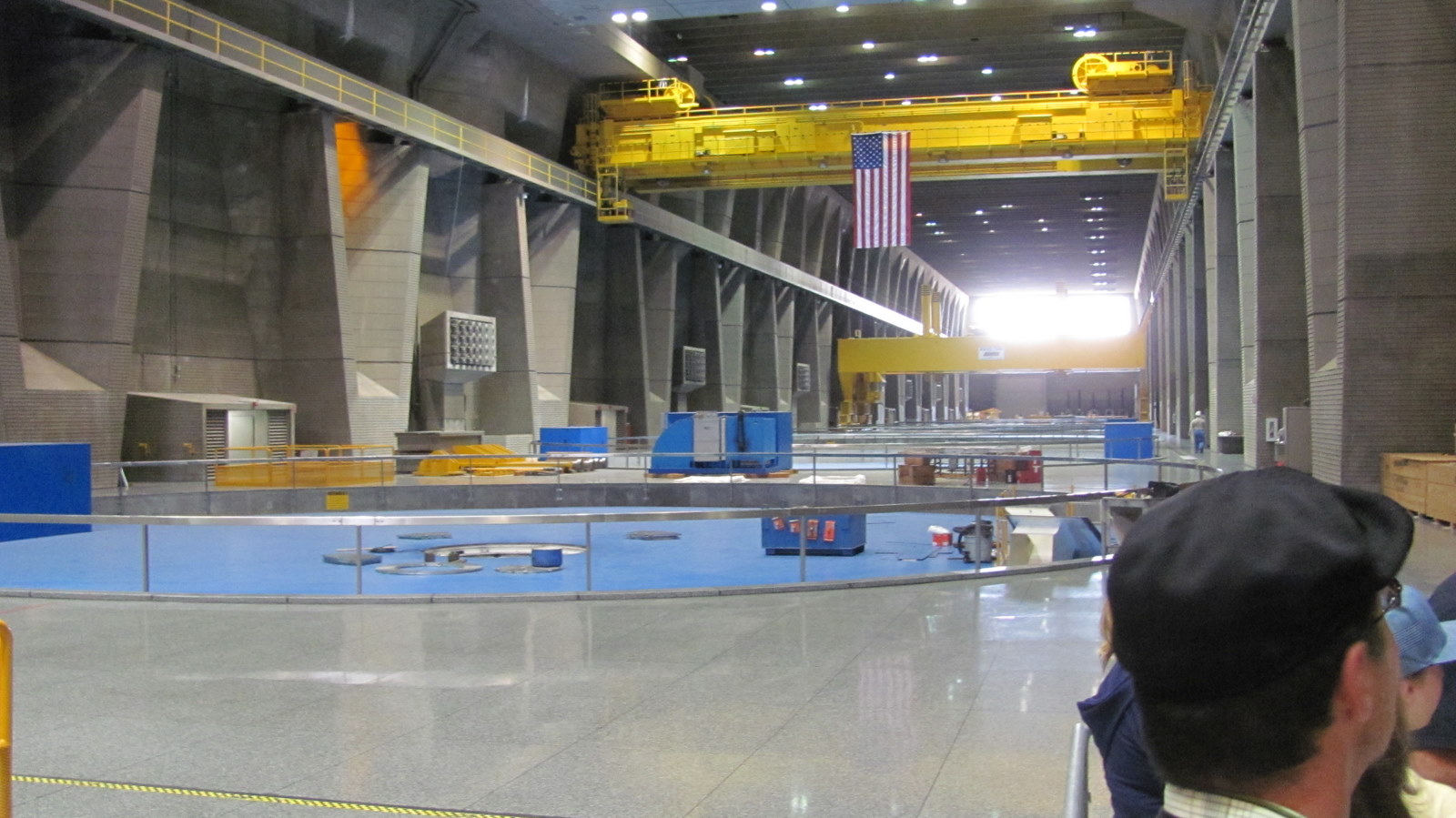
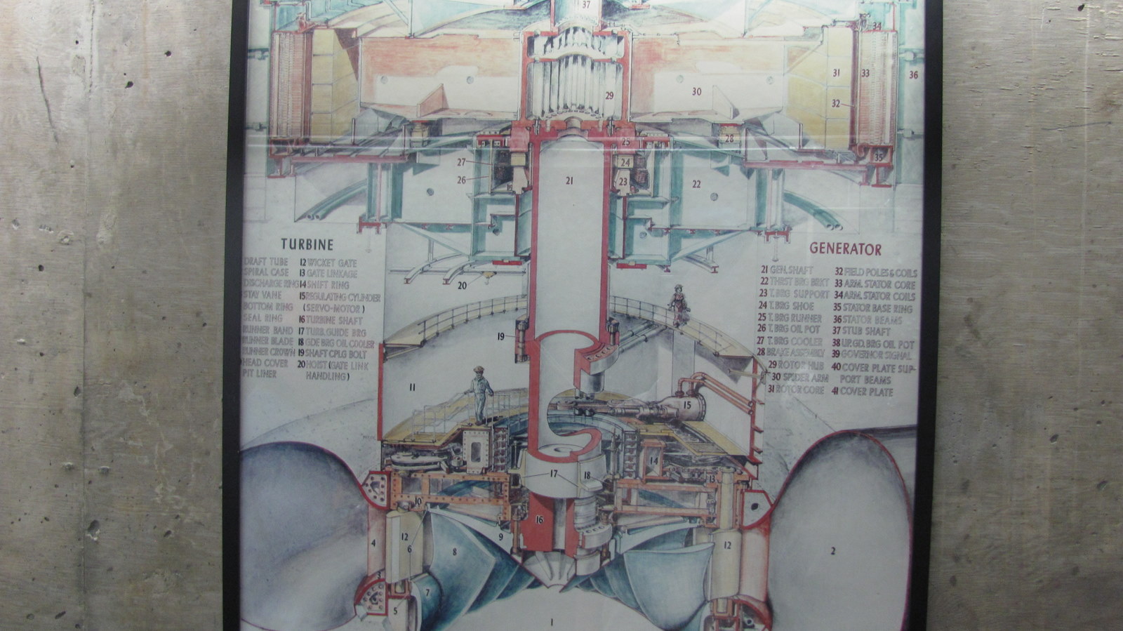
The tour of the power house made one feel like a pebble in an ocean. Everything in the powerhouse was "big"! The stainless steel shaft that connected the water turbines to the generators was over 11 feet in diameter. It spun at 72 RPMs. The generator rotor was over 60 foot in diameter. It takes several hours to get the generator spinning up to speed if shutdown. As we walked around in the powerhouse, you could feel the "rumble of water" passing through the huge turbine wheels. The rumble of the huge volumes of water, plus the generator noise, made of a very noisy environment.
The tour guide stated that each powerhouse has one operator and an assistant operator that runs the systems. Hard to imagine such large equipment operated by only two people per shift.
A laser show is shown each night. The gates to the dam were opened, allowing rushing white water to cover the dam face, and the laser show was shown on the rushing white water. You could feel the roar of the water in air, hear the voice over and see the presentation on the face of the 300 foot dam. The presentation gave a history of the dam and uses of the water. If in the area, it is a must see wonder.
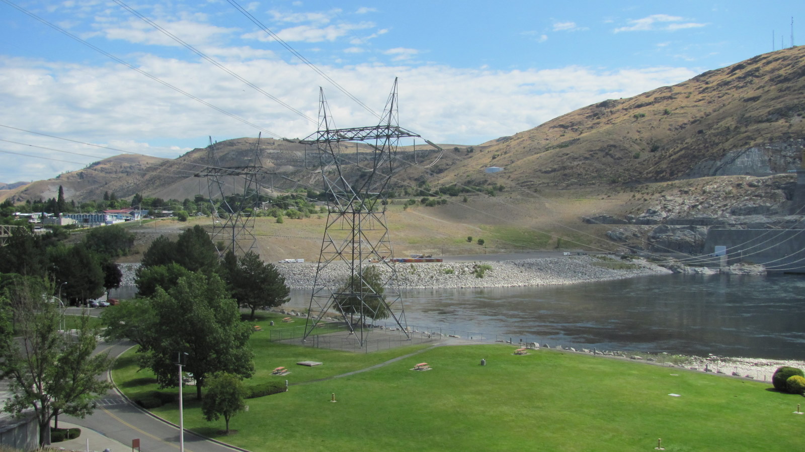
A picture of Grand Coulee Dam from the visitors center. A huge concrete structure. The Number 3 Powerhouse is on the left. Water is not going over the top in this photo. Only leakage from the gates show water running down the dam face. All water released is going through all the generators.
A picture showing one of the many high voltage power transmission lines leaving the dam. Notice the dry, brown color of the hill side. To have so much water available in the Columbia River, the local area is bone dry, unless irrigated.
Our tour guide. She was a college student working a summer job for Bureau of Reclamation. She said both of her parents are school teachers, thus the reason for her loud voice.
One of six huge pin stocks that feed water to powerhouse #3. The roar of water could be loudly heard even though each pin stock is encased in concrete and buried into the rock mountain next to the powerhouse.
Notice the irregular shape of the powerhouse concrete wall. The design is said to increase structural strength in case of a pin stock rupture. The wall would not collapse against the pressure of the water. Check out the huge transformers on the side of the building. They boast up the voltage to feed the many transmission lines to supply the Northwest USA.
A shot across the powerhouse showing the generator rotor slots. The rotors are 60 foot across and require a huge crane to lift out if maintenance is required. The air in the building vibrated from the tremendous water flow going through the water turbines turning the huge generators.
Overview picture of the generator system.
A shot from the top of the dam. It is 350 foot to the water line. The water seen is leakage from one of the huge gates that release water when needed.
A photo from the top of the dam. We are near the headwaters of the Columbia river. Even this far up, the Columbia is a very high flowing river.
Small movie clip taken from the top of the dam. Remember, the movie is taken from 350 feet up.
I toured the dam using the official tour given by the Bureau of Reclamation service. Security was tight and required that you empty all pockets for inspection and walk through a metal detector. We then boarded a small bus and headed for power house #3, which is the newest and biggest. The tour guide was very informative and security escorted us throughout the tour.
Leading from the dam were many high electrical lines. Lee said at night she could hear them humming. I would highly recommend this side trip. This is not a tourist area, but does offer incredible sights and memories. If you want to see what our government did in the old days (before the politicians were more busy keeping their job than doing their job), come to the Grand Coulee Dam.
As we were leaving Coulee Dam, the drive was very beautiful. A mixture of rough lands with the blend of water only nature can do.
This is Banks Lake taken from the highway that follows it for a 100 miles. Banks Lake is used as an irrigation waterway from water pumped from Grand Coulee Dam. Water is transported to farmers used to grow their crops.
The highway was carved through rocks in many places.
Another picture from the highway of Banks Lake. It was beautiful.
We are entering the beautiful wheat fields.
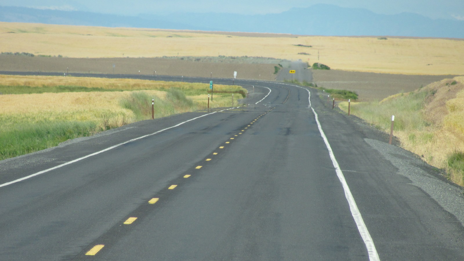
The road goes on forever.
As we started to climb up the lower Cascade loop, we came upon a town called "Leavenworth, Washington". Most of the buildings are built with a Bavarian alpine look. A unique town.
Our trip up the east coast included a stop in Washington, DC. We enjoy both enjoy history and seek any opportunity to learn more about our country. Washington, DC has always proven to be top rated for us. On this trip we targeted the Washington Mall, being where all the museums and government buildings are located.
We stayed at Cherry Hill RV Park located on the beltway around Washington. Subway and Metro travel is easily accessible from the RV park. We tried to drive a minimum while in Washington because the traffic is terrible. Good advice is to use the subway whenever possible.
Oh Boy! I have my ticket. Let's go!
Humm... Which way did you say we were going?
Here is a movie clip of a subway train pulling into a station. It was easy to get to anywhere in the city and the stations were well lit and clean.
We went to both the Air and Space Museum located on the Mall and the Air and Space Museum, in the Udvar-Hazy Center located at Dulles Airport. We spent a day at each of the facilities, but especially enjoyed the Udvar-Hazy Center at Dulles. Check out the movie clip taken at the Udvar-Hazy Center at Dulles.
Air and Space Museum, Udvar-Hazy Center, Dulles Airport
While in Washington, we decided to try our luck at riding Segways. Several companies offered a tour riding a Segway. We chose our company and showed up at the reservation time. I was very apprehensive of Lee riding a Segway, but was blindsided by her ease of learning to ride. She had a short lesson at the Segway dealer and it looked so easy. Then came my time to ride. Well, it is safe to say it took me longer to learn how to ride than her. When I jumped up on the Segway, the thing kicked out from under me. The guy helping us kept telling me not to grab the handle, well it took awhile to understand the dynamics of the machine. But we learned how simple it was to ride, and we were off. Each of us had a headset to listen to the leader talking about all the sites. It was great!
Lee and I, on our Segways, in front of the White House. For those asking, no Michelle did not invite us in, but we did see here peeking through the drapes...!
Lee did great, even in crowds.
Lee is getting brave with her Segway. Here she is balanced with one hand, while drinking water with the other.
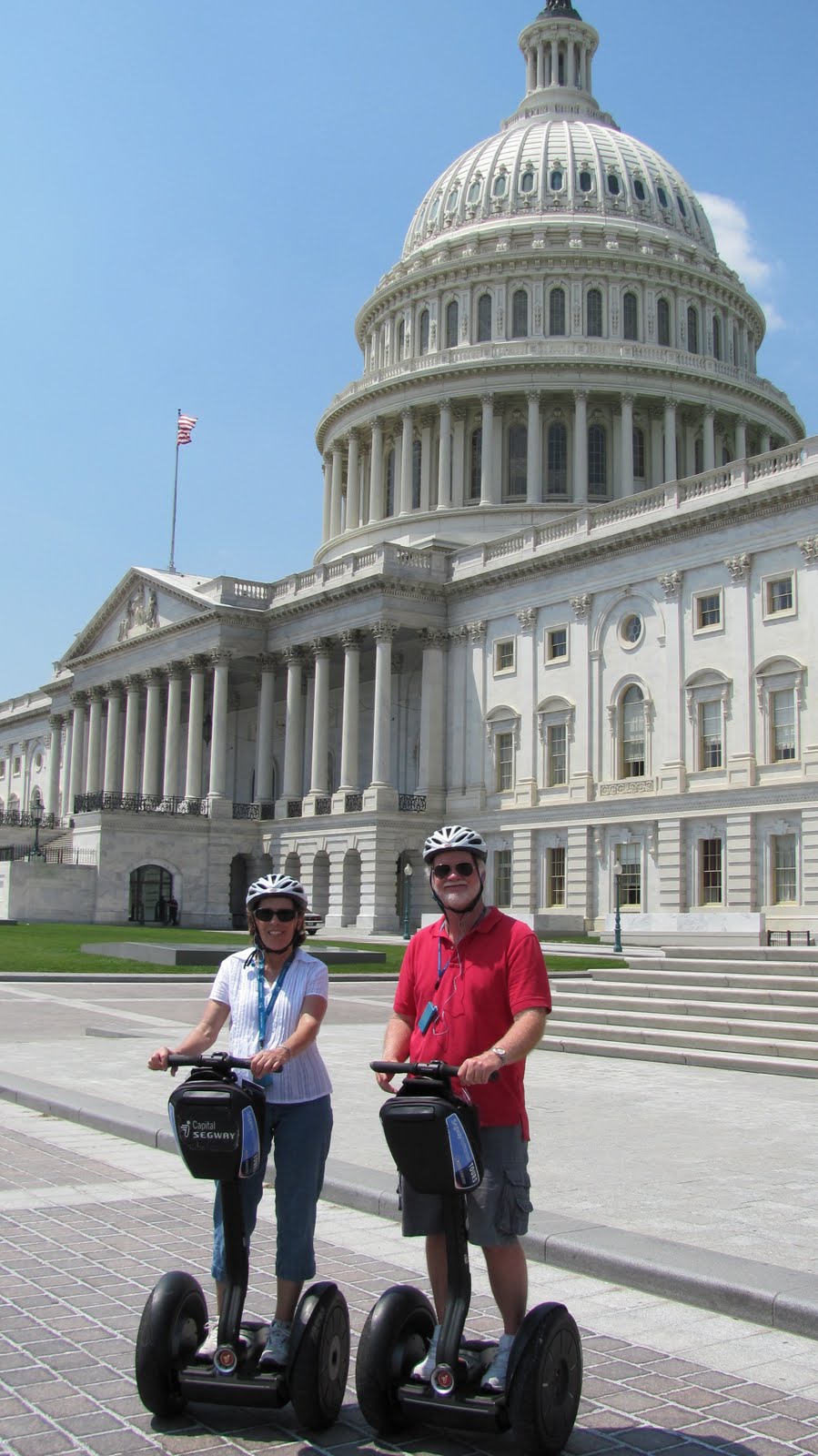
Here we both are in front of the House of Congress. A comment on the Segways, you can really cover a lot of ground riding these things. We traveled over 7 1/2 miles in 45 minutes. It sure beats walking.