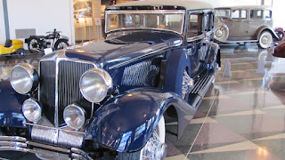
While we were in the Auburn, Indiana area we decided to tour the The Auburn Cord Duesenberg Automobile Museum, a national historic landmark. Wow! I'm I glad we did. MSNBC News named the Auburn Cord Dusenberg Automobile Museum one of the “Top Ten Gearhead Destinations in the United States.” I don't claim to be a gearhead, but was amazed at how things were done in the early 1900's.
You can walk the same hallways as the automotive giants of yesterday. Touring the museum will give you an impression of what a day at Auburn Automobile Company must have been like in the 1930s. There are many displays to look at and read. The building that was the original sales building and the factory is open for tours.
If you want to experience a pure touch of elegance of the 1930's, this is the place. I was amazed at the craftsmanship used in the production of the Auburn. Each car on display was detailed and perfect. There was even an Auburn that had over 150,000 miles on it, in original condition. Besides for a few oil leaks and barely noticeable wear on the seats, it looked great. These cars were expensive, but quality was part of the process.
I have grouped numerous pictures together for your viewing pleasure. Enjoy!
Monday, October 11, 2010
Friday, October 8, 2010
The Farm
We have been fortunate to meet and be friends with two very special individuals. Jerry and Rita represent what I see as working class farmers and we are pleased to know them and consider them our friends. In 2006, we spent several weeks helping them with their harvest. It was great. Working the farm and enjoying their friendship was a life memory.
On this trip, we were pressed for time, so we only spent three weeks, but what a great time. Jerry showed off his new tractor and it was indeed a first class work horse. It was like driving a Lincoln Towncar, except it had tractor wheels.
On this trip, we were pressed for time, so we only spent three weeks, but what a great time. Jerry showed off his new tractor and it was indeed a first class work horse. It was like driving a Lincoln Towncar, except it had tractor wheels.
Jerry's new tractor. It was a fantastic machine.
The trees were putting on their fall display of colors. These trees were in their front yard.
To admire people that are such hard workers and represent the American farmer is easy. These are great people.
Sunday, August 29, 2010
Maritimes, Part 9 (Last One)
Now that we have reached the furthest point north of our trip, it is time to head south. We left Saint Anthony driving south along the same route we had traveled a few days earlier. Remember, there was only one north/south highway and it hugged the coastline. As we headed south, we were greeted with Hurricane Earl. This hurricane had gone through the eastern United States, through Nova Scotia, then up the St Lawrence Waterway. That meant as we were driving south along the coast Hurricane Earl was blowing to our right side.
The wind gusts were so strong, the wave would crash into rocks on the shoreline and splash up onto the highway, or hit vehicles passing by. We had no problems with the wind, however, several other RV'ers had awning damage due to wind blowing so strong, causing the awning to unfurl.


The next day we boarded a ferry for our trip to Prince Edward Island. The one-hour ferry ride was uneventful, but interesting. The roads were narrow on PEI, but we were able to find the RV park without incident.
We left PEI by driving over the Confederation Bridge. It is a very long bridge on the ocean. The Confederation Bridge joins the eastern Canadian provinces of Prince Edward Island and New Brunswick, making travel throughout the Maritimes easy and convenient. The curved, 12.9 kilometre (8 mile) long bridge is the longest in the world crossing ice-covered water, and a decade after its construction, it endures as one of Canada’s top engineering achievements of the 20th century.
The wind gusts were so strong, the wave would crash into rocks on the shoreline and splash up onto the highway, or hit vehicles passing by. We had no problems with the wind, however, several other RV'ers had awning damage due to wind blowing so strong, causing the awning to unfurl.
If you look on the road you can see where water had splashed up on the road from the waves crashing into the shoreline rocks.
The two photos above do not do the storm justice. The wind was blowing so hard, the surf was blowing on the vehicles going down the road.
A
The hurricane force winds tore this road sign apart. Man, was the wind blowing!
As we headed south we stopped along the way to explore. We found a small fishing village and bought these beautiful salmon fillets for that night's dinner.
The salmon fish were great!
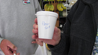
But we also found flour for sale in cup-size containers. Look at the price for this small cup of flour.
"aux Basques" is the location of the ferry landing for the ferry heading back to Nova Scotia. We stayed at the Grand Codroy RV Park on Doyles Road, near the ferry landing, the night before we loaded on the ferry. The park was 15 miles from the ferry landing, so we drove "noise to tail" caravan style to the ferry. We all came in together to help sort out the ferry tickets. The ferry crossing was a six hour ferry ride in smooth seas on a beautiful day.
Leaving the RV park we were driving noise to tail, caravan style.
We were coming down the hill towards the ferry. You can see the ocean in the background.
We are coming up the ferry loading gates.
Once inside the loading area, we had to drive through a "de-contamination" booth. As we drove through, a chemical sprayed the undercarriage of the rig. Apparently, a certain mold commonly found in Newfoundland soil was not wanted in Nova Scotia. The process was painless, simply drive through.
Here is the ferry backing into the ferry loading slip. This is a huge ship, with two car decks.

The ferry is very slowly backing into the vehicle slip.
We finally got to load. A comment about Canadian ferry schedules, they are very loose. Meaning, if the schedule says it will leave at 3:00 pm, plan on 4:00 pm departure. It seems to be the accepted standard mode of operation for the government-operated ferry system.

We're off! We are leaving Newfoundland.
Here is Frank, Rita and Lee gathering for departure.
We are unloading from the car deck of the ferry. The loading and unloading process runs very well.
We headed to Louisburg, a Canadian Parks National Park. The Fortress of Louisburg is a National Historic Site of Canada. It is the largest historical society reconstruction in North America. As you weave your way through the cobblestone streets and buildings of this former French stronghold, your senses awaken with the sights, sounds and smells of an 18th-century fortress.
This city was built by the French for creating a process for the cod fish to be harvested and returned to France for consumption. Apparently, cod fish can be salted, and dried and shipped, not requiring refrigeration. When the cod was received in France, it could be soaked in water and reconstituted as fresh fish. This purpose built city was the jewel of France. But naturally, the British wanted it. So throughout the years several battles took place to see who would control Louisburg.
We had to drive through the countryside to get to the seaside town of Louisburg. There is a new Louisburg next to the historic fortress.
Here is a model of the layout of the original city.
The main building has been refurbished. This building housed officers of the military.
Lee with one of the characters dressed for that period.
This guy is preparing to give a "long gun" demonstration. A crude weapon indeed.
When he fired the gun, it sounded like a cannon. Also, it had a pretty kick to it.
The office of the General. Notice the stone work. These buildings were built using native stone.
We had a dinner one evening that was intended to mimic how people ate in the 1800s. We all ate under a tent and of course we had to all wear a hat of the period. We arrived late and the hat I got was not my first choice. It was all in good fun. A "winch" trolled through the dining area sitting on guys' laps. Well, guess who she picked? We enjoyed the evening, and, of course, the entertainment!
The next day we boarded a ferry for our trip to Prince Edward Island. The one-hour ferry ride was uneventful, but interesting. The roads were narrow on PEI, but we were able to find the RV park without incident.
Loading the PEI ferry.
One of the surprises we had while on PEI was getting a history lesson on "Anne of Green Gables". I remember hearing of this book, but did not realize the significance of the book in other countries. For example, Japan uses the book as mandatory reading for their school system. Needless to say, there were many more Japanese tourists here than Americans.
Lucy Maud Montgomery was actually the author of the book. She lived on PEI and based the content in the book around her grandparents farm.
The barn at the "Green Gables".
The farm house.
We had our farewell dinner at a local church. The food was great and fellowship was excellent.
Here is Rita with her lobster eating bid on. All lobster eaters were wearing them.
Here are all the PEI lobsters ready for eating. My lobster was great.
Yummy!
This trip to the Canadian Maritimes was a major trip for us. We especially enjoyed the history lessons we learned about Canada. It became so obvious to me that Canadians know much more about American history thnt Americans know about Canadian history.
I would recommend this trip to anyone.
Saturday, August 21, 2010
Maritimes, Part 8
While in Halifax, Newfoundland, we took advantage of more local sites. We were amazed of how many things we had learned during our history classes that related to this area. Marconi is the person credited with the first wireless radio transmission, thus launching a communication revolution. The location where Marconi received this first radio signal was located in Halifax at a location called "Signal Hill". The hill is located high above the city and offers a great view of the city and the harbor. The day we toured this facility, it was cold and windy, very windy.
From the top of Signal Hill we enjoyed a commanding view of Halifax and the Halifax harbor. Look closely in the picture and you will see several large tug boats used in oil operations in the Atlantic between Newfoundland and Greenland.
.
Lee and I standing at the Parks Canada sign for Signal Hill. It was cold and very windy. Notice I was wearing shorts. I must think we are still in Texas.
An information sign relating to Marconi and Signal Hill.
The building where Marconi's workshop and radio equipment was used. The information stated that during the winter, as much as seven feet of snow can accumulate on the hill.
We also visited the Basilica of Saint John the Baptist. The church was built in the 1800s and was beautiful. The church is still actively used.
Information sign.
A very impressive structure, especially when you consider it was built in the late 1800s.
Stained glass windows in the church mounted high in the loft area of the church.
A representation of John the Baptist.
A picture of the sanctuary. Everything in the church was built to last.
We stopped in at Cape Spear, the most easterly point in North America. As you can see by our dress, it was cold and windy.
We are now driving across Newfoundland on one of the few paved roads. We are on the Trans Canadian Highway. You can see in the picture that the road crews blasted through solid rock to put in the roadbed.
You can see Gander in 246 KM ahead. We had an overnight stop in Gander to attend a dinner, with the topic of discussion of the Gander Air Traffic Control Center. An unknown factoid for me was that Gander, Newfoundland, is the location of Gander ATC, the busiest ATC in the world. All international flights to and from Europe are handled through Gander ATC. Also, when the USA experienced the 911 tragedy, aircraft coming from Europe were denied landing rights in the United States. The Gander airport allowed landing of these stranded international flights. There were so many stranded passengers, residents in the small town of Gander would come by the airport, pick up complete strangers and bring them to their home for a shower and meal. If Newfoundland were to export anything, it should the universal kindness these citizens demonstrated.
On our way across Newfoundland, we passed the road that exits to the Nova Scotia Ferry. We will later return to this ferry landing to exit Newfoundland going back to Nova Scotia.
We stopped at a small village named Springdale, NFL. Springdale was a small town located on the coast that had excellent Newfie hospitality. We learned of the Newfie traditional ceremony called Screech, where you ate an internal organ of a fish and chased it down with a strong alcohol drink. I wondered if these guys were not laughing at seeing Americans doing this.
Here we are assembling for a meal.
Rita, Lee and I at the dinner table. Rita is one of those precious ladies that we were glad to have met. She and her husband, Frank, were great people and we felt fortunate to have enjoyed their company.
Part of the entertainment for the evening.
Here we are at another feast enjoying the entertainment and a mussels dinner all in an outdoor tent. Mussels are a shellfish that grow in the nutrient rich waters surrounding Newfoundland.
We got our mussels and were ready to eat. The story is Lee was not going to eat any of those things (Her words exactly.). Well, after she tasted them, she and Rita were going back to the pot so many times, I thought the guy cooking them was going to ask one of them out for a date.
I do have to admit, the delicate, sweet taste was unexpected.
Our entertainment for the evening, "Newfie" style.
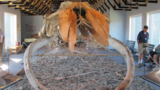
Info on the whale.
Look at the huge bones that support the big mouth-opening for the whale to scoop up its meal.
We finally headed north on the main paved road that hugs the coast. Along the way we visited numerous fishing villages lining the coast. It was a great example of what impact government decisions have on daily lives. Canada placed a moratorium on cod fishing for 10 years within their territorial waters. As benign as that may sound, if you were a fisherman with a fleet of 10 boats one day actively fishing, then the next day you are out of business, that changes everything. The fishing villages along the coast of the Northern Peninsula in Newfoundland were devastated. What we saw was what ten years of of government decisions had done to the fishing communities.
We were headed for St. Anthony, NFL. It is located on the northern point of the northern peninsula of Newfoundland. It is the location on a Viking "long house" (Click here for information Vikings in Newfoundland) believed to be one of the first Viking settlements in North America.
Inside the Viking long house, a warm fire was a welcome site. The wind was blowing and very cold.
The walls of the Viking long house were made from sod. The ground was rich with plant life and made great sod material for buildings.
Lee and Jenny standing outside of the Viking long house. Jimmy and Jenny were "tail gunners" for the trip. They were great travelers from Florida.
These signs were all along the highway. Every day at the Tracks morning drivers meeting, the words "Watch for moose on the highways" were echoed.
Did I mention there are a lot of moose in this part of the world. However, we did not see a one!
The drive was very scenic and sparse. In this remote area, life is centered on the coast line.
A picture of the rough coastline.
Our campsite in St. Anthony, Newfoundland. RV facilities were minimum compared to US RV parks. 50 amp service was rare, but most had 30 amp service. We were fine with either.
Lee and I with Newfoundland lighthouse in the distance. The sky was blue and the temperature was perfect (You can see I am still wearing my shorts). What a great day to be alive.
Subscribe to:
Comments (Atom)


